Hiking to the Col d'Arves


Presentation
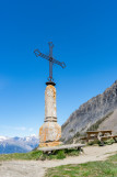
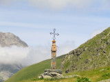
The Col d'Arves is an historical passage at 1748 meters of altitude, frequently taken before the construction of the D926 in 1894. At the summit : Baroque cross and viewpoint on Saint Jean de Maurienne, Villarembert, Fontcouverte et Jarrier.
One way : about 40 minutes
For more information : See the tourist office of Saint Jean d'Arves.
Hike detailed in the topo-guide on sale at the tourism office (5€).
For more information : See the tourist office of Saint Jean d'Arves.
Hike detailed in the topo-guide on sale at the tourism office (5€).
Opening day(s)
From 30 April to 17 November(every year)
Every day
General
- Pedestrian sports :
- Pedestrian sports
- Hiking itinerary
Comfort
- Parking :
- Parking
Contact
Hiking to the Col d'Arves
73530
Saint-Jean-d'Arves
Phone : +33 4 79 59 73 30
Download

Destination
Randonnée au Col d'Arves
73530
Saint-Jean-d'Arves
GPS coordinates
Latitude : 45.213775
Longitude : 6.265486